The 40th International congress of the Indian National Cartographic Association (INCA) began at Kolkata today. The three-day meet organised by the National Atlas & Thematic Mapping Organisation (NATMO), of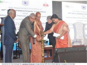 the Union Ministry of Science and Technology, has the focal theme of ‘Digital Mapping Innovations in Make India Initiatives’.
About 500 experts from all over the country as well as from abroad are participating in this Congress. They will make presentations on their research-oriented findings on the focal theme. The aim is to explore how digital mapping innovations like ‘Drone’, ‘Artificial Intelligence’, which can now generate large-scale maps with higher accuracy (up to 10 cm), can help the administrators and planners establish more effective utility projects at the grass-root level.
Inaugurating the congress, Governor of West Bengal, Jagdeep Dhankar lauded the various activities taken by NATMO to utilise the advances made in the areas of cartography for the benefit of the country.
INCA is the only professional body of cartographers and geospatial technologists. It was founded on 7th August, 1979 at Hyderabad.
It has become one of the biggest organizations of its kind in the world.
Presiding over the inaugural programme, Dr. Tapati Banerjee, Director, NATMO and President, INCA, noted that cartography or science of map making is as old as human civilization and it has been playing an important role in the activities of mankind from the very beginning of civilization. “Cartography, like architecture, is the art, science, and technology of map production and reproduction. It is one of the media of communication like graphicacy. It is a representation of any segment of spatial reality with a view to communicate and message most effectively”, she said.
The Surveyor General of India and the Director General of Geological Survey of India, Mr. Nabin Tomar underlined that from ancient times cartographers are making maps which helped travellers and in the excavation of minerals. Now, their role has become wider. They are also helping to chalk out development plans.
Also Read : Business and Human Rights: 10 Years of an Arduous Journey
The Congress is being held both in physical and virtual mode, keeping in view the pandemic situations. The programme includes special lectures and plenary sessions, apart from technical sessions on a wide range of sub-themes from `Reprogramming of Traditional Cartographic Practices into Digital and Alternative Cartography’, and `ICT and interactive map services in smart planning for food and livelihood security’ to `Water Resource Management’.(India Science Wire)