If you think that the news of cyclones hitting the western coast of India keeps on increasing year after year, you are not wrong. Tauktae signals an already perceivable change in patterns over the western coast of India. The brute force with which cyclone Tauktae attacked the western coast is evident in the damage it caused in its wake. It is now established among scientists that the western coast of India is indeed going through drastic changes in its cyclone formation patterns. To add to our woes, cyclone Yaas is forming in the Bay of Bengal and will soon hit the eastern coast. To pinpoint the culprit behind these beastly cyclones, we need to first understand the nitty-gritty of cyclone formation.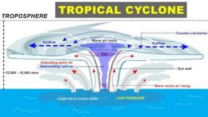
Cyclones are formed in conditions where a low-pressure area is created, surrounded by high-pressure areas. The winds move from a high-pressure area to low pressure area but get deflected due to the Coriolis force of the earth, formed by the movement of the Earth on its axis. These deflecting winds form a circular pattern around the low-pressure area, leading to the birth of a cyclone. The catch here is that the low-pressure area is formed when warm air rises from the surface of the water, leaving behind less air. The warm air goes up and cools down to form a high-pressure area around the low-pressure area. The continuing warm air at the surface feeds into this cycle until a cyclone is formed. Cyclones do not pose a threat if they dissipate in the sea, which they generally do. But with recent encounters such as Nisarga, Vayu, and Tauktae, the cyclones moved closer or parallel to the shores and hit the lands with force.
Also Read : Cyclone Tauktae Passes Mumbai; Gujarat Braces for Impact
Now, warm air is formed by the warm surface of the water. So, the increased frequency of the cyclones is connected to the increased warming of sea waters. You can now probably guess where I am going with this; Global warming ringing a bell, anyone? The reason the Arabian sea conventionally saw fewer cyclone formations over its waters is that it had Sea Surface Temperature (SST) lower than that of the Bay of Bengal by 1 to 2 degrees Celsius. SST of the Bay of Bengal is around 28 degrees Celsius. In the last 40 years, SST in the Arabian Sea has increased by 1.2-1.4 degrees Celsius, with SST reaching 30-31 degrees Celsius around Panaji, Goa. There are records of previous cyclones to attest to this notion.
The Arabian Sea annually saw one cyclone form in its waters between 1891-2017, while its counterpart, Bay of Bengal, saw four such form every year. Things took a turn from 2017 onwards. In 2018, three cyclones formed over the Arabian Sea compared to four in the Bay of Bengal. The year 2019 was the record-breaker with the Arabian sea outcompeting the Bay of Bengal; five cyclones formed in the Arabian Sea and just three in the Bay of Bengal. Last year, things calmed down a bit with two cyclones in the Arabian Sea and three in the Bay of Bengal. Another aspect of the change in pattern is the rapid intensification of the cyclones. Cyclones are said to rapidly intensify when wind speeds increase by 55kmph or more within 24 hours. Cyclone Tauktae took Indian Metrological Department (IMD) by surprise this year; IMD had on Monday, May 17 at 2:20 AM forecast that Tauktae would intensify into a very severe cyclonic storm on Tuesday, May 18 early morning, but by 8:15 AM on Monday itself Tauktae developed into a very severe cyclonic storm. This poses future challenges for IMD to come up with new, better forecasting methods and the National Disaster Response Force (NDRF) to evacuate risky areas in real-time.
With no relief in global carbon emissions and other unsustainable practices, sadly, tropical cyclones like Tauktae will become commonplace in the Arabian Sea in the years to come.