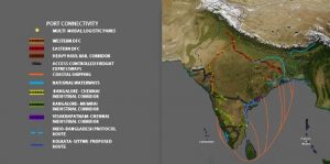
 India’s great sea necklace, SagarMala Programme is the mega port-led development project that encompasses all the crucial elements for the growth of the economy. Alongside the four pillars viz., modernisation of ports and establishment of new commercial ports, strengthening of port connectivity, enlarging port-led industrialisation and maximising the coastal community development, SagarMala acknowledges the need, and aims at mainstreaming of the inland waterways for the optimum realisation of its potential as a national carrier to complement and complete the modal-mix of the railways, roadways and airways.
The flagship programme of the Government of India, SagarMala showcases to the world and Maritime Forum India’s capabilities and excellence in the sphere.
India has an extensive network of inland waterways, comprising the total navigable length of 20,236 km of rivers, canals, backwaters and creeks. Out of this, 17,980 km of rivers and 2,256 km of canals can be used by mechanised crafts.
“Bulk transportation by waterways has remained noticeably under-utilised in the country till now as compared to countries and regions like the United States, China and the European Union.”
SagarMala envisages enabling inland waterways to become the transport lifeline of the country. These waterways will provide an additional channel for transportation but also serve as recreational centers.
Notably, till the year 2016, only five National Waterways had been notified by separate Acts. The Inland Waterways Authority of India (IWAI), an entity under the Ministry of Shipping, identified 106 new waterways as viable waterways in India for phased development as National Waterways.
Also read: Uttar Pradesh’s Ghagra River is soon to be a National Waterway
In April 2016, the Government of India, through a single piece of legislation, declared a total of 111 National Waterways including the five existing ones. The five earlier Acts were repealed and the National Waterways Act, 2016 came into being (published in the Gazette of India, Extraordinary, Part-II, Section-I, dated 26 March, 2016 as an Act No. 17 of 2016).
NW-1, 2, and 3 are already operational. Cargo as well as passenger/cruise vessels are plying on these waterways. The Detailed Project Report (DPR) for development of NW-4 and 5 was completed in 2010. The DPR of NW-5 was updated in 2014. For the newly declared 106 NWs, techno-economic feasibility studies have been initiated.
“Waterways currently contribute around six per cent to India’s transportation modal mix, which is significantly much lower as compared to that of in developed economies and some of the developing economies as well.”
It is estimated that coastal shipping traffic of about 180-200 Million Metric Tonne Per Annum (MMTPA) can be achieved with the current and planned capacities across coal, cement, iron and steel, food grains, fertilisers, POL (Petroleum, Oil and Lubricants) by 2025. Additionally, about 60-70 MMTPA of cargo is expected to be moved via inland waterways by 2025.
Domestic waterways are more cost-effective. Another equally important fact is that they are an environment-friendly means of bulk transportation. The cost of transporting coal via coastal shipping is one-sixth of the cost of transporting it by railways. In consideration of the above, National Waterways 1, 2, 4 and 5 can play an important role in transportation.
National Waterway-1
The Ganga-Bhagirathi-Hooghly river system between Haldia (Sagar) and Allahabad (1,620 km) was declared as National Waterway-1 (NW-1) in 1986. Since then, IWAI is carrying out various developmental works on the waterway for improvement of its navigability and development and maintenance of other infrastructure such as terminals and navigation aids as laid down in the IWAI Act, 1985 (82 of 1985).
As per the Act, IWAI is, inter alia, responsible for developing and regulating the national waterways for navigation.
Nowadays, the NW-1 is being used by various cargo vessels, Over-Dimensional Cargo (ODC) carriers, tourist vessels and IWAI vessels etc. Further, IWAI has planned to develop 2.0 meters least assured depth (LAD) up to Varanasi in place of Ghazipur i.e. about 133 km stretch with enhanced target of 2.0 meters depth against 1.5 meters.
National Waterway-2
The river Brahmaputra having a length of 891 Km between Dhubri and Sadiya (Bangladesh border) was declared as National Waterway-2 (NW-2) on September 1, 1988.
IWAI is maintaining a navigable depth of 2.5m in Bangladesh Border- Neamati (629 km), 2.0 m in Neamati–Dibrugarh (139 Km) and 1.5m in Dibrugarh–Sadiya (Oriumghat) stretch.
Also read: Yamuna revival plans kicked off
At present, the waterway is being used by vessels of the Government of Assam, Central Inland Water Corporation Limited (CIWTC), Border Security Forces, tourism organisations and other private operators.
“Long cruise tourist vessels are making voyages between Sivasagar near Dibrugarh and Manas Wildlife Sanctuary near Jogighopa regularly.”
ODC is also transported through the waterway from time to time. Transportation of POL was also experienced through this waterway from Silghat to Budg-Budg (West Bengal) and Baghmari (Bangladesh).
National Waterway-3
The West Coast Canal or National Waterway-3 is a 168-km stretch of this inland navigational route located in Kerala and runs from Kollam to Kottapuram. It was declared a National Waterway in 1993. In addition to the main stretch, Champakara and Udyogmandal canals are navigable and connect the industrial centres of Kochi to Kochi Port. It is the first National Waterway in the country with round-the-clock navigation facilities along the entire stretch. It has been extended to Kozhikode as per National Waterways Bill, 2015.
 National Waterway-4
This is a 1,095-km long inland stretch declared as an Indian National Waterway on November 24, 2008 under the Provisions of National Waterways Bill, 2006 and is currently under development. It connects the Indian states of Telangana, Andhra Pradesh, Tamil Nadu and the union territory of Puducherry.
The NW-4 runs along the Coromandal Coast through Kakinada, Eluru, Commanur, Buckingham Canals and also through part of Krishna and Godavari rivers in South India.
It was earlier scheduled for completion by 2013. The National Waterways Act, 2016 has extended the length of NW-4 from 1078 km to 2890 km by connecting the Krishna and Godavari rivers. The project will be undertaken in three phases with first phase starting in October, 2017 which is to be completed by June, 2019.
National Waterway-5
NW-5 covers the state of Odisha and a part of West Bengal. It runs to a total length of 623 km, out of which 91 km is within West Bengal and the remaining 532 km is in Odisha. It was declared a National Waterway in November 2008.
The NW-5 consists of the stretches from Talcher to Dhamra on the Brahmani river – a distance of 265 km including the Kharsua and Dhamra river systems, the Geonkhali–Charbatia stretch of the East Coast Canal of 217 km, the Charbatia–Dhamra stretch of Matai River of 40 km and the Mangalgadi–Paradip stretch of the Mahanadi River Delta which runs for 101 km. The waterway also includes a 91 km stretch in Bengal between Geonkhali and Nasirabad, West Bengal.
“SagarMala has been planned to promote coastal shipping as a mode of freight transportation and hence initiated various infrastructural development at ports and supporting infrastructure using rail, road and waterways to facilitate coastal movement.”
These include development of dedicated coastal berths, bunkering and storage at ports and creation of supporting hinterland transport infrastructure with last mile connectivity.
The optimised modal mix using inland waterways and coastal shipping will not only reduce logistics cost but also cut down emissions and reduce energy and fuel consumption. It is estimated that the reduction of 12.5 MT in total CO2 emission (2.5 per cent of current emission through transport sector) and 1 million KL in liquid fuel consumption (1.5 per cent of current liquid fuel consumption by transport sector) can be achieved via modal-mix optimisation. Reduction in the logistics cost promotes the manufacturing sector and enhances export competitiveness.