On the intervening night of 15–16 June, Indian and Chinese troops engaged in a violent clash in Ladakh’s Galwan Valley. As per the Indian Army, 20 Indian soldiers were killed in action (KIA), while there were unconfirmed casualties on the Chinese side. The violence came on the heels of confrontations in Ladakh’s Pangong Tso starting 5-6 May and in Sikkim’s Naku La on 9May. The Galwan clash was only the latest in a long list of escalations and de-escalations on the disputed border between the two countries that have mostly resulted in a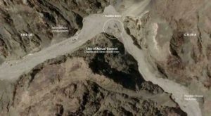 stalemate, barring the 1962 Sino-Indian war. In fact, as Bertil Lintner writes in his 2018 book China’s India War: Collision Course on the Roof of the World,the Galwan incident is similar to an earlier clash between the two countries in Ladakh’s Kongka La in October 1959, the year the initial border skirmishes started. Lintner further writes that in Kongka La, 17 Indian soldiers were KIA when the Chinese, in what they called an “act of self-defence”, started “sudden and aggressive firing” on Indian troops.
The periodic clashes and the resulting uncertain peace in the region beg an obvious question: how do the two countries end up in these standoffs time and again? The answer to this question holds the key to understanding how the two Asian giants approach the issue of border management, and how that, in turn, affects the border dispute.
The Dispute
The source of the dispute is the undemarcated Line of Actual Control (LAC) in the eastern sector (Arunachal Pradesh and Sikkim) and the western sector (Ladakh). The middle sector in Himachal Pradesh and Uttarakhand has been largely undisputed.
The contemporary roots of the dispute go as far back as the 1950 invasion of Tibet by China after which China and independent India came to share international borders for the first time in history.
Also Read : Border Disputes in Sino-Indian Relations: Past, Present and Prospects
Eventually in the mid-1950s, Indian authorities discovered that China had built a 180 km long road through Ladakh’s Aksai Chin region connecting its newly occupied territories of Tibet and Xinjiang. Subsequently, a series of letters were exchanged between Jawaharlal Nehru and then Chinese premier Zhou Enlai during November 1959 and March 1960. The letters not only reflect a fundamental disagreement about the events that transpired during the initial border skirmishes and the contested territorial claims of the two countries, but also lay the groundwork for how the dispute shaped up eventually.
Ambiguity vs Restraint
The table below compares statements by the two premiers in the series of letters on various aspects of the dispute to understand the contrasting approaches taken by the policymakers of the two countries:
|
Topic/Issue |
Zhou Enlai |
Jawaharlal Nehru |
| On what sparked the dispute | As the Sino-Indian boundary has never been delimited…I am afraid that, if no fully appropriate solution is worked out by the two governments, border clashes, which both sides do not want to see, may again occur in the future. | This entire frontier was a peaceful one for a long time…It is only recently that conflicts and difficulties have arisen…not because of any action that we have taken. The cause of the recent troubles is action taken from your side of the frontier. |
| Nature of Patrolling/Control | Most of these places, which definitely belong to China, were occupied successively by armed Indian personnel after the signing of the 1954 Agreement (Panchsheel). Now the Indian Government asserts that this area has all along been under Indian jurisdiction. This is absolutely unconvincing. | India had not posted any army personnel anywhere at or near the international border…check-posts were manned by civil constabulary, equipped with light arms…to deal with traders or others going along the recognised routes…check-posts were not intended for any aggressive purpose or for any persons crossing the border. |
| Proposal for Western Sector/Aksai Chin | China and India each withdraw 20 km from the line up to which each side exercises actual control in the west, and the two sides refrain from again sending their armed personnel to be stationed in and patrol the zones from which they have evacuated, but still maintain civil administrative personnel and unarmed police. | India should withdraw to the west of the line shown as the international boundary in Chinese maps from 1956. China should withdraw to the east of the international boundary described by India. The area is almost entirely uninhabited…thus not necessary to maintain administrative personnel. |
Although not enough to provide the full extent of the contested claims of the two countries, several themes emerge from these excerpts.
One, China considered the lack of boundary delimitation as the cause of the dispute, while Indian ever felt the need to delimit the boundary.Presumably, this was because it consisted of a historically accepted natural frontier of watersheds, valleys, and mountains between the subcontinent and the Tibetan plateau. India also clearly identified Chinese aggression as the source of the dispute. Further reading of the exchange of notes between India’s foreign ministry and its Chinese counterpart around the same time as the Nehru–Enlai letters reveals that India recognised lack of ‘demarcation’ as the key issue. Delimitation is possible when two parties agree to a common boundary, while demarcation is the act of marking such a boundary on the ground through extensive surveys.
 Two, it is clear that India did not feel the need to effectively fortify its claimed borders in Ladakh and elsewhere along the Himalayas. The lack of any threat from Tibet and the desolate high-altitude nature of these regions could be the primary reasons for this. China, however, was more steadfast in recognising the importance of having police and administrative personnel on the ground. Post the defeat of 1962, India did gradually strengthen its border outposts along the LAC and invested in border infrastructure. However, a clear policy of restraint can be observed on India’s part throughout the history of the dispute in attempting to take back lost territories, with China having de-facto control over Aksai Chin since 1962. Most prominently, this restraint is reflected in the terms of the first bilateral agreement on the border issue that the two countries signed in 1993, which stated,“Pending an ultimate solution to the boundary question between the two countries, the two sides shall strictly respect and observe the line of actual control between the two sides.”
Also Read : Chalo Dilli: Tibetans call for Freedom
Three, there is an ambiguity that results from the lack of delimitation and demarcation of the border. This ambiguity provides a conducive environment to periodic contestations, particularly from a country like China with a documented history of aggression. Since the war of 1962, some of the key incidents of Chinese aggression along the LAC have been recorded at Sikkim’s Nathu La in 1967, Arunachal’s Tulung La and Sumdorong Chu Valley in 1975 and 1987, Ladakh’s Daulat Beg Oldi in 2013, and the Doklam plateau in 2017.
A similar tendency for contestation could be seen in China’s behaviour during the Galwan clash. The Chinese had never laid claim over this area throughout the history of the dispute, yet they have made a fresh claim.
This goes clearly against the understanding reached as part of the 1993 agreement mentioned above. It is the ambiguity borne out of the undemarcated nature of the border that allows the Chinese to renege on a bilateral agreement. In this context, exchanging maps regarding claimed boundaries is a way to reach a commonly agreed LAC. However, even after signing five agreements on the border issue in 1993, 1996, 2005, 2012, and 2013, China has only exchanged maps for the middle sector. This stalled process of exchange of maps, in turn, feeds the ambiguous nature of the border. This ambiguity works strategically in China’s favour because it allows them to keep laying fresh claims on undemarcated territories.
Ending the Periodic Chinese Belligerence: The Way Forward
The India–China border issue is primarily a contest between two parties with polar opposite approaches to border management. One side clearly seeks to keep the LAC ambiguous and benefits from it, while the other side practices strategic restraint and seeks to maintain the status quo ante during a border standoff. While this unlikely pairing of belligerents has resulted in multiple stalemates over the years, the current situation is far from being peaceful. Brutal clashes like the one in Galwan Valley highlight the fundamental flaws in the various confidence building measures taken up by India and China since the 1980s. Comparatively speaking, out of the 20 neighbours with which China has had border disputes, it has reached resolution with at least eight, including former rivals like Vietnam and Russia with which resolution was achieved after an armed conflict. Certainly, India needs to re-evaluate its current approach to the boundary question with China, as restraint on its part has only yielded a ‘peace’ that is hostage to periodic Chinese belligerence till now.
(This article is part of content collaboration with the Social & Political Research Foundation (SPRF), New Delhi).