Natural hazards occur swiftly with little warning; therefore, predicting and/or mitigating them are a hard task. God’s Own Country, Kerala, has been experiencing frequent and untimely heavy rainfall, floods and landslides for some time. Kerala, with the Western Ghats running throughout its length and being located in a tropical monsoon setting, is prone to landslides. Landslide is a broad term encompassing different types of earth movements ranging from rock fall to earth flow based on the material involved and from debris avalanche to creep based on the velocity. Landslides also differ from other natural hazards for being influenced by several factors like rock and its structures, soil thickness and its textures, slope, groundwater fluctuations, geomorphology, distance from the drainage, rainfall, other natural hazards like earthquake and volcanism, land-use changes and other anthropogenic interferences. Hence, studying landslides demands a holistic approach. Even though landslides are influenced by several factors, studying landslides are pretty easy when compared to other hazards as these occur on the surface of the earth.
Factors Influencing Landslides
The factors influencing landslides in Kerala are mainly four, solely or combined:
Rainfall: The landslides occurring in Kerala are temporal to monsoon season. Hence, the main triggering factor for landslides is rainfall. The quantity of rainfall, as well as the duration, has to be studied while considering rainfall. For example, during the week spanning from 8 to 14 August 2019, when the State of Kerala witnessed the two most dangerous landslides, Kavalappara and Puthumala, the rainfall was about 400 per cent to 650 per cent in excess than any other years during this time. But the cumulative rainfall for the entire June to August remains the same or little less or more. This shows that the high-intensity rainfall in a short duration of time is the real triggering mechanism for landslide occurrences in Kerala.
Slope: Slope is, perhaps, the single most important geomorphological attribute to be considered in any landslide analysis. The presence of a slope is the primary requisite for a landslide to occur since a component of the gravitational force tangential to the surface is required to generate the shearing stress.
Also Read : Rebuilding Kerala Un Pdna Exercise To Not Count Just Damage But Rebuild Better
A landslide occurs when this downslope component of the force exceeds the shearing strength of the material.
In tropical areas, mass movements of earth are generally confined to slopes between 30º and 60º. As the slope angle increases, shear stress in soil or other unconsolidated material generally increases as well.
Rock and soil: The soil seen above the older massive hard rock in the highland of Kerala is so young and is in meta-stable condition. Once the entire column is saturated with water, this mass of soil flows downhill along with the contact between soil and rock, under the influence of gravity.
Anthropogenic activities: The surface of the earth is continuously altered by human beings for their sustenance. Unscientific land-use practices on steep slopes, quarrying without considering the terrain conditions, and road and building constructions on unfavourable slopes can contribute to landslide occurrences. Deforestation is another, particularly, a significant factor to be considered.
Developing Early Warning System
The first and foremost part of forecasting landslides is dividing an area into discrete zones on the basis of the probability of landslide occurrences, called the landslide hazard zonation or landslide susceptibility mapping. There are several models available and the selection of a model depends upon the terrain conditions of the study area. Each model depends on several influencing factors and most models are compatible on a GIS (geographic information system) environment. The purpose of dividing an area into discrete zones, on the basis of the probability of landslide occurrence, is to prioritize areas where early warning systems are to be installed.
As the landslides in Kerala are temporalto monsoon season,by studying and understanding the intensity and duration of rainfall, one could understand at what threshold the land fails and falls. This is also dependant on the soil thickness. Thus, by understanding the amount of rainfall required to saturate the soil helps in developing an early warning system. This is what is called a rainfall threshold analysis.
An example depicting the rainfall threshold analysis can be described here. Suppose a 100 mm rainfall event spanning 3days is required to saturate a 1 m thickness soil column, and if the area experiences 70 mm rainfall in two days, then we can come to a conclusion that 30 mm rainfall is required for a landslide to occur. It is not imperative that a landslide will occur every time the rainfall crosses the threshold value; rather, it would be ideal time to issue an early warning so that the community is prepared for a potential landslide event. A predictability rate of 10 per cent is generally a fair success rate of the forecast.
Improving Early Warning System
The early warning system can be improvised through a network of rain gauges that are automatic and now-casting. Through this, hourly warnings can be issued. The rainfall data can be supplemented by installing additional gadgets like inclinometer (that measures the inclination of a terrain), extensometer (that measures the extension or expansion of a crack or land), piezometer (that measures the pressure induced by groundwater fluctuations) and geophone (that measures any vibrations within the earth) synchronizing with rain gauges. This will improve the early warning system.
The early warning system can also be further improved by developing a mobile application that has facilities of crowdsourcing.
This can make common man approachable to early warning instead of waiting for the governmental agency to issue warnings.
Some Monstrous Landslides in the History
Landslides associated with earthquake, volcanism and flood are the deadliest combinations of natural hazards that have ever occurred. The 8.5-magnitude Haiyuan Earthquake, considered as the world’s second-deadliest earthquake of the 20th Century, generated a series of 675 major landslides causing massive destruction to lives (1,00,000) and property. The natural calamity, which struck the rural district of Haiyuan, China on the evening of 16 December 1920, is a result of the loosening of the soil due to earthquake tremors. This earthquake was followed by a severe rainfall that engulfed an area of approximately 20,000 sq.km with a stream of soil and debris. Similarly, the 7.8-magnitude Gorkha earthquake that occurred on 25 April 2015 in Nepal was followed by a dramatic ‘cloudburst’ that triggered more than 20,000 landslides. The landslides isolated several hilly hamlets from the main distribution system.
Also Read : Disasters In Odisha A Story Of Resilience And Near Success
The eruption of Nevadodel Ruiz volcano in Colombia exemplifies the disaster formed by the combination of volcanism and landslides. Volcanism isusually associated with the expulsion of a huge volume of ash and debris, called pyroclastics, which are usually deposited on the steep as well as vulnerable locations of the volcano. This glacier-covered volcano melted due to the heat from the hot molten lava. The water melt of ice together with the pyroclastic material engulfed the downhill villages with slurry and 23,000 people were submerged to death.
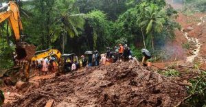
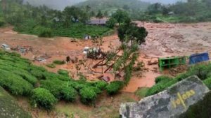
Flood and associated landslides are the next deadliest combination. The Kedarnath flood-mudslide of June 2013 killed around 5,700 people in the Himalayan state of Uttarakhand. The huge volume of mud and rock inundated towns and villages for several days. The 2018 flood that occurred in Kerala also resulted in several landslides. More than 3,700 landslides, sprinkled along with the hilly districts, during this irregular rainfall event, compounded with failure in dam management. It was the simple reality of steep terrain being bombarded with too much water. When the torrential rain bore down on the slopes of the Western Ghats, the water percolated under the surface of the soil and tried to flow downhill.
Monitoring Landslides Using State-of-the-art Techniques
Persistent Scatterer Interferometry (PSI) technique, a radar-based technique, helps to identify areas of potential failure through continuous monitoring. The temporal ground deformation information obtained through PSI can estimate the time of failure. The global coverage of satellite-based radar makes it attractive for landslide monitoring.
Landslide, like any other natural hazards, is difficult to predict as it comes with little warning. But, by utilizing the state-of-the-art techniques, the effects of landslides can be minimized. The ultimate aim of the science of natural hazards is also the same, ‘Learning from disasters for a better tomorrow’.
(The writer, a renowned geologist, is an Assistant Professor in Geology Department in Kerala University).